A powerful Western Disturbance is sweeping across Jammu and Kashmir, and its impact is set to linger far longer than initially anticipated. The India Meteorological Department (IMD) has issued a fresh weather alert warning of continuous rain in the plains and heavy snowfall across upper reaches of the Union Territory — with conditions expected to remain unsettled right through April 10, 2026.
Travellers, commuters, and residents across both divisions are urged to exercise caution as the region braces for one of the more prolonged early-April weather spells in recent years.
What Is Causing This Sudden Shift in J&K’s Weather?
The abrupt change in weather conditions across Jammu and Kashmir is being driven by a fresh Western Disturbance originating in the Mediterranean region. As this system moves eastward, it draws significant moisture into the Himalayan range — triggering widespread rain across the plains and snowfall at higher elevations.
Weather experts explain that when such disturbances interact with the Western Himalayas, the moisture-laden air rises sharply along mountain slopes, cools rapidly, and precipitates — resulting in the combination of valley rainfall and mountain snowfall that J&K is currently experiencing. The current system is described as strong and well-organised, which explains both its intensity and its extended timeline through April 10.
IMD Fresh Alert: Rain, Snow and Cloudy Skies Across the Region
The IMD has confirmed that the Western Himalayan region will experience intermittent spells of precipitation throughout this period. Skies will remain predominantly cloudy across both Jammu and Kashmir divisions, with upper regions receiving light to moderate rain and snowfall on most days.
Kashmir Weather, a widely followed weather monitoring handle on X (formerly Twitter), issued a specific alert warning residents and travellers:
“A strong Western Disturbance is set to impact Jammu and Kashmir over the next 36 hours, bringing widespread moderate to heavy rain showers across the UT. Higher reaches and mountain passes, including Zojila, Sinthan Top, Mughal Road, Sadhna Top, and Razdan Top, are likely to witness fresh snowfall.”
Three-Day Forecast: April 3 to April 5 at a Glance
The local MeT Department has broken down the weather progression over the next three days:
April 3 — Today: Generally cloudy conditions with intermittent light to moderate rain across the plains. Snowfall reported in higher reaches. Thunder, hailstorms, and gusty winds of 30 to 50 kmph expected at scattered locations, particularly during afternoon hours.
April 4 — Peak Activity: The most intense day of this wet spell. A high probability of moderate to heavy rain across the Jammu division and fresh snowfall across the Kashmir Valley and mountain passes. Residents are advised to avoid non-essential travel. The MeT Department has flagged this as the day of maximum weather impact.
April 5 — Marginal Improvement: Partly cloudy skies with only isolated light rain expected. Conditions will ease slightly but will not fully clear. Another active spell is already building for the following week.
Mountain Passes on High Alert: Zojila, Sinthan, Mughal Road Affected
Some of the most critical mountain passes and high-altitude routes in Jammu and Kashmir are directly in the path of this weather system:
- Zojila Pass (connecting Srinagar to Ladakh)
- Sinthan Top (Anantnag to Kishtwar route)
- Mughal Road (Shopian to Poonch)
- Sadhna Top (Kupwara region)
- Razdan Top (Ganderbal district)
Fresh and potentially heavy snowfall at these passes raises the risk of slippery road surfaces, reduced visibility, and temporary closures. Authorities managing these routes are expected to issue status updates based on accumulation levels and clearing capacity.
Landslide and Highway Risk: Jammu-Srinagar NH on Watch
Beyond the mountain passes, the Jammu-Srinagar National Highway — the primary artery connecting both divisions — remains under a landslide, mudslide, and shooting stones advisory from the MeT Department. Rain-soaked slopes along this route are particularly vulnerable during prolonged wet spells.
Commuters are strongly advised to:
- Check real-time road status with the Traffic Police control room before departing
- Avoid night travel on the highway between April 3 and April 5
- Carry essentials in case of unexpected halts or delays
Tourist Destinations Facing Fresh Snowfall
Three of Jammu and Kashmir’s most visited tourist destinations are expected to receive fresh snowfall during this weather system:
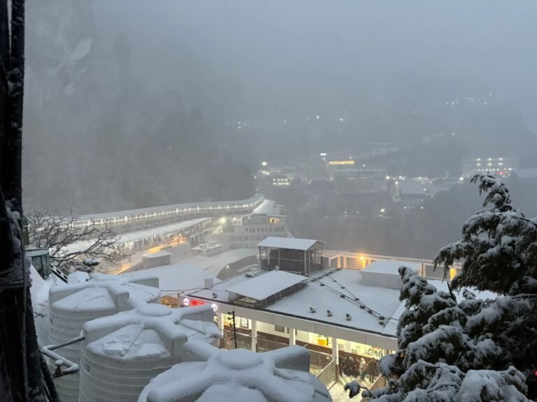
Gulmarg: Already one of India’s premier ski destinations, Gulmarg is likely to see additional snowfall that could impact gondola operations and road access to the resort town.
Sonamarg: The Sindh Valley meadow, currently accessible after the winter closure, may see fresh snow that temporarily affects the newly reopened route.
Pahalgam: The Lidder Valley town and its surrounding trekking routes will likely experience both rain at lower elevations and snow higher up, including in areas like Baisaran and Aru Valley.
Tourists already present at these locations or planning visits between April 3 and April 10 are advised to stay in close contact with local hospitality providers and monitor official updates before moving between locations.
Travel Advisory: What You Need to Know Before You Go
The combination of heavy rain, mountain snowfall, and strong winds creates a specific set of travel risks during this period:
Road Transport: Mountain roads and highways are particularly vulnerable to slippery conditions, reduced visibility, and debris flow. Travel time on all major routes may increase significantly.
Air Connectivity: Low cloud cover and poor visibility can result in flight delays or cancellations at Srinagar International Airport and Jammu Airport during peak activity days.
Trekking and Outdoor Activities: All high-altitude treks, including those in the Pahalgam, Gulmarg, and Sonamarg zones, should be deferred until conditions stabilise after April 10.
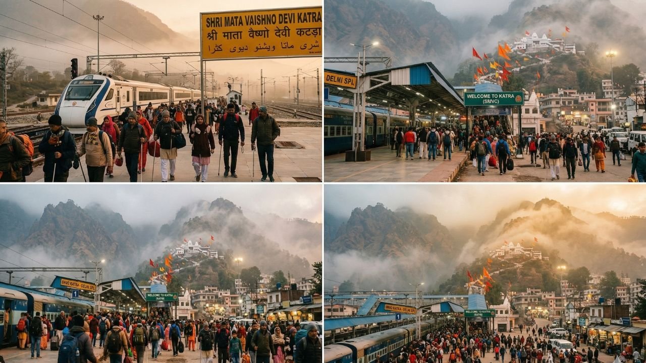
Vaishno Devi Yatra: Pilgrims travelling to Katra and undertaking the trek to the Vaishno Devi Shrine should factor in rain and wind conditions, particularly on April 3 and April 4. The track can become slippery during sustained rainfall.
Agriculture Advisory: Farmers Asked to Halt Operations
The MeT Department and agricultural authorities have jointly advised farmers and orchardists across Jammu and Kashmir to suspend all spraying operations and outdoor farming activities on April 3 and April 4. High winds combined with rain make spraying ineffective and risk damage to crops.
Orchardists in the Kashmir Valley — particularly those managing apple orchards at a sensitive pre-bloom or bloom stage — face heightened risk. A significant drop in daytime temperatures during this period could also affect fruit set and early crop development.
Another Wet Spell Approaching: April 7–9 Already on Radar
Even as the current system plays out, meteorologists are tracking a second potential weather spell between April 7 and April 9. This means the window of settled weather between the two systems may be narrow — possibly just April 6.
With the active Western Disturbance influence now confirmed to extend through April 10, Jammu and Kashmir is effectively entering a prolonged unsettled phase. Residents and visitors are advised to plan around this extended timeline rather than expecting conditions to normalise after April 5.
Current Temperatures Across Key Locations
Minimum temperatures recorded on Friday morning across Jammu and Kashmir:
Kashmir Division:
- Srinagar: 11.2°C
- Gulmarg: 4.0°C
- Pahalgam: 6.2°C
Jammu Division:
- Jammu City: 19.8°C
- Katra: 19.0°C
- Batote: 13.5°C
- Banihal: 12.1°C
- Bhaderwah: 10.0°C
A further drop in daytime highs is expected across all locations through April 5, with temperatures likely recovering gradually from April 6 onward — weather permitting.
Winter Deficit and Water Level Recovery: The Bigger Picture
This prolonged wet spell arrives in a broader context worth noting. Jammu and Kashmir recorded a deficit in both rainfall and snowfall during the winter season, raising early concerns about water availability for drinking and irrigation through the summer months.
The situation improved considerably through February and March, when the plains received adequate rainfall and higher elevations saw light to moderate snowfall. As a result, water levels across local rivers, mountain streams, lakes, springs, and wells have risen — partially addressing the earlier deficit.
The current April spell, while disruptive in the short term, may contribute further to groundwater recharge and reservoir levels heading into the summer demand season.
Quick Reference: Key Alerts at a Glance
| Date | Weather Condition | Key Risk |
|---|---|---|
| April 3 | Rain, thunder, hail, gusty winds | Slippery roads, low visibility |
| April 4 | Peak rain and snowfall | Landslides, highway disruption |
| April 5 | Partial improvement | Isolated rain, cautious travel |
| April 6 | Brief settled window | Monitor forecasts |
| April 7–9 | Fresh wet spell approaching | Renewed disruption possible |
| April 10 | Western Disturbance influence ends | Gradual normalisation expected |